Wednesday, August 6, 2008

Home to Wisconsin !


We left Frankfort at 6 am with a good weather forecast for crossing Lake Michigan. There were a few swells for the first part of the trip but that was okay. Then, all of a sudden, the fog rolled in and we couldn't see 50 feet. This didn't last too long, but when that lifted, here's a view of the lake....


Here is the entrance to Sturgeon Bay. A welcome sight.


Finally, here we are. Because I learned so much this time about handling the boat, these shirts seemed appropriate.


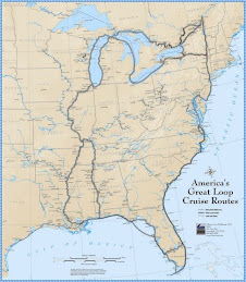
After 243 days, about 6600 miles, 102 locks, passing under hundreds of bridges, 4 canals, too many rivers to mention, a couple of nail-biting times (for me), a new engine, a new transmission, a new drive shaft, but most importantly, many more memories of places we went and people we met, our Great Adventure is over !


Start: July 28, 2007

Finish: August 5, 2008


Monday, August 4, 2008

North Channel to Crossing Our Wake

We spent a couple of nights at anchor in the North Channel where Darrell and Bob did some fishing again. We had another nice dinner of great small mouth bass.
At this anchorage, which was our last night there, Beth and I had picked out 3 possible anchorages. The guys chose this last one. However, when we got there, we found it was VERY small....first the entrance to it was barely visible, and then it was only about 20 feet wide. Our boats are 14 feet wide. Holding our breaths though, we made it in. The book had assurred us that once we were in though, it was plenty deep with plenty of room. Well, not exactly....it was deep enough in the middle but the whole space was only about 100 feet by 300 feet. The first picture shows Bob stringing a line to one shore which he tied to a tree.


This is a line to the other shore...with storms forecast, we didn't want to swing too much. Rather, we didn't have any room to swing !


This shows the entrance....leaving in the morning, we again held our breaths.


Before leaving though, the anchors had to be raised. Beth here looks like she's wondering what to do about the stuff on the anchor...and this was after they got most of the stuff off by dropping it down again !


She looks a little more relieved here !!! Bob and Darrell said that this anchorage will forevermore be known as "Beth and Margaret's anchorage"..


Here we pass a cottage within the US border near Drummond Island where we cleared customs...


This is a picture of Drummond Island Yacht Club where the Customs officers are located. We had to wait a little while because they didn't come on duty until noon, but once they came, we were cleared in just a few minutes.


Although we started our "loop" in Superior, we actually closed our loop when we crossed the St. Mary's River. This is about where the Coast Guard stopped us last year. This cruise ship was docked here now.


And, because we were so close, we went up to where this boat was on shore to see if any more work had been done on it since we saw it last....We think the entrepreneurs ran out of steam. It was supposed to be a Bed and Breakfast...


To celebrate, we bought some steaks and had Darrell and Beth over for dinner, including champagne of course. This is Bob and Darrell cooking---it was windy. Bob is in charge of the meat and Darrell is holding the umbrella.


Leaving the DeTour Marina the next day, we headed out into Lake Huron with the destination of Mackinaw City Marina.
The first lighthouse is the DeTour LH--I don't think I was able to get a picture of it last year as the water was pretty rough as I recall. Today it was very calm.


As we neared our destination, we passed Mackinac Island. This is a picture from a distance.


This lighthouse is at the entrance to the Mackinac Island harbor.


And of course, the Grand Hotel !!!


Across from Mackinac Island is Round Island which has its lighthouse too.


This is a view of the fort there on the Island. We have been there a couple of times so we didn't go there this time.


Our first sight of lakers...with a view of the Mackinac Bridge. It celebrated its 50th birthday this year.


We enjoyed Mackinaw City...it has a nice waterfront and the downtown is filled with shops and restaurants. Returning to Michigan, of course we had to get some pasties again !

Leaving, we had this wonderful view of the Mackinac Bridge.


From here we plan to go to Charlevoix (it turned out to be Leland), then Frankfort, MI. From there, we will cross Lake Michigan to Sturgeon Bay where we will leave the boat. Home soon !

Monday, July 28, 2008

Georgian Bay Scenes-July 21 to July 28


Leaving Port Severn, our destination was Henry's for fish on Frying Pan Island. However, before we could get to Henry's, Georgian Bay greeted us with a BIG Storm. Luckily, we were not in one of the narrow, rocky channels when it hit, so we were able to stay off-shore in deep water until the storm passed. Henry's was reputed to serve the best pickerel (we know this as walleye). We must be spoiled....


The next night we anchored in Hopewell Bay. Nice place but a little tricky to get in to...I had to be on the bow watching for rocks. We were able to stop before we hit one. Bob and Darrell went fishing and caught 4 nice small mouth bass.


Not only did they catch the fish, but they cleaned them and cooked them too !! These fish were MUCH better than Henry's !


We (the gals) figure we should get at least one more fish dinner to justify that Canadian fishing license !!!


Along many of the rocks, we would see these sort of rock formations....we've seen them before in South America, but can't remember the meaning....


Every eveining Bob and Darrell would plot out the route for the next day....sorry Darrell, I didn't get all of you in the picture !


This is Point au Baril lighthouse, which we passed before we headed out for a long stretch of the Georgian Bay. Bob thinks it was about 35 miles---I think it was about 15. Could look it up, but it was uneventful anyway....until we got into the small boat channel again................more rocks.


This picture just said "photograph me".


This was another lighthouse somewhere along the way...we tend to lose track of the days, and as well as of the day of the week,etc.


Actually, we pretty much know what day of the week it is , according to the pill box.


This was the lighthouse as we turned into Byng Inlet where we stayed at a marina for the night. This is in the NE part of Georgian Bay.


This an example of the narrow channels--L'Attitude Changer is leading...were they to meet another trawler of the same size, there would not be much room. It's red buoy on the right side....


We caught these kids jumping into the water as we were going into Parry Sound...apparantly the parents (or some adults) were in the boat below.


Another view of the kids in the water....


There are all varieties of cottages on Georgian Bay...in the southern part, the shoreline is dotted with homes of all sorts. I have thought that every Canadian must have a cottage in these parts, there are so many.


As we go further north, the cottages are spaced further and further apart. But electric cables are strung (under water) to many of the islands.


Some are really remote....................


I'm not sure I'd like to be this far away from everything...our place in Wisconsin looks pretty good right now.


This place says "Paradise something...."


Leaving Britt in Byng Inlet we decided to head for Killarney. The weather didn't co-operate so we anchored between Tie and Strawberry Island in the Bustard Islands. This shows us going for a dinghy ride and I collected some flowers for our dinner table.


Here are our two boats anchored together....we started with one anchor. Darrell and Beth put in another anchor the opposite way. Later in the evening, Bob got in the dinghy and took another anchor and tied it to the shore. That makes 3 on day 1.


Day 2 was a relaxing day.....look at Bob! They tried fishing, but Bob apparantly caught the only fish in this bay. According to a lady in a cottage, no one catches fish here because of the rocky bottom. They gave it up then...


These next few pictures show the narrow, rocky channels we went through. Remember, red on the right.


We had to zig-zag through many channels.... But, we only got off course once---that required a detour out to the bay and then follow the narrow, rocky channel back in again...We are feeling pretty lucky to have missed so many of the shoals...


On the last night at anchorage, we had yet another anchor down---Darrell's Big Bertha. This weighed 60#. It did hold us for the night as the winds were predicted to be very strong.

Next day, we left--after the anchors were raised (this took 1 hour) with the destination of Little Current across the Bay instead of the small boat channel. This will be the start of the North Channel.


Tuesday, July 22, 2008

Big Chute to Port Severn


Leaving Big Chute, we'll go into the Small Chute canal. We know it's here somewhere....hmmm.


This is another one of those narrow canals---rocky on both sides. Wouldn't want to meet anyone here.

These signs are posted at the entrances to these canals. I'll be glad when we're through with this Trent Severn Waterway !


But, they are pretty.....


This cottage has its resident moose.
There are many, many cottages along the way. They don't have much lawn though in this rocky landscape !

After spending the night on the wall at the Port Severn lock, we are lined up bright and early to go through. Here we are, down in the lock---our last one for the trip--# 102!

Next posting will be on Georgian Bay. Everyone says the scenery is stunning. It has been so pretty to this point, I can't imagine that it could be better.